


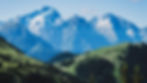
Stage 3 - Southern Alps
Ecrins - Belledonne - Vercors

497 km
20 à 35 J
Distance
Elevation +
26.800 m
Duration


Mountains similar as the Northern Alps, but with the added bonus of sunshine, the Hautes-Alpes is a paradise for hikers who venture there.
The difference in altitude per km of this stage is one of the highest in the HexaTrek. A difficult stage with tricky sections, but a guaranteed immersion in nature.
Less touristy than its closest neighbour, the Hautes-Alpes are discovered during this great crossing before joining the Pre-Alps, the Vercors and the Baronnies region.
THE SUNNY ALPS


NATIONAL PARK
LES ÉCRINS
The Tour des Écrins is the only place on the route where the HexaTrek allows itself a 140km diversions to see the best of this place.
The plateau of Emparis, the Meije, the lake of Lauvitel... the tour of the Ecrins, it's almost 8000m of difference in altitude in a place cut off from the world.
REGIONAL PARK
LE VERCORS
A real UFO of the HexaTrek, the Mont Aiguille stands like a statue in the middle of the chaotic scenery of the Vercors cliffs. And it is above all the emblem of the HexaTrek! The high plateaus are a haven of peace outside of time and the Archiane cirque a masterpiece of nature.
MASSIF
Discover the hidden treasures of these mountains. The Seven Laux lake, the Pra pass or the Crozet lake, this mountain range is as surprising from its own lair as it is for the views it offers of the Chartreuse or Bauges massif.
BELLEDONNE
INFORMATION & TRANSPORT
Seasonalities, places of departure and arrival, means of transport

The airports of Avignon or Montélimar are the closest to the town of St Martin.
The nearest airport to Le Lautaret is Grenoble
Lautaret
Viviers
Lautaret

Departure
Viviers
Arrival
Jui - Oct
Season

This location is close to a motorway exit. Bus routes are available
Viviers
Lautaret
To get to the Col du Lautaret, there is only one possibility apart from the car, it is the bus line (Bourg D'Oisans / Briançon)

Snow risks are high from October and before May.
In winter, mountaineering equipment is mandatory.

Viviers
The nearest main lines are in Orange and Montélimar. The nearest train station is Bollène-la-Croisière where you can take a bus to Saint Martin d'Ardèche.
The nearest train station is in Grenoble
Lautaret
TOP 10 MOST BEAUTIFUL LANDSCAPE

.jpg)
THE AIGUILLES D'ARVES
The Aiguilles d'Arves are the emblem of the Maurienne.
The Aiguilles d'Arves dominate the Arvan valley. The most beautiful trilogy of the Alps according to the locals
.jpg)
ACHARD LAKE
This pretty high altitude lake located at the southern end of the Belledonne massif, will offer you a landscape that looks like Canadian rocks. In good weather, you will have an exceptional view of the Taillefer massif.

LA MEIJE
The Meije is without doubt one of the most beautiful mountains in the Alps. Majestic, it dominates from the top of its 3983m the high valley of the Romanche where the two pretty little villages of La Grave and Villar d'Arène are nestled, each surrounded by their hamlets.

GUICHARD LAKE
Lake Guichard is famous for its panorama of the Aiguilles d'Arves which are reflected in it. An ideal mirror to admire the sunrises and sunsets in the Maurienne.

THE MONT AIGUILLE
Among the wonders of the Dauphiné, Mont Aiguille is remarkable for its shape, which changes according to the point of view, sometimes needle and sometimes tooth.
More than an emblem of the region, Mont Aiguille is also the emblem of the HexaTrek

LE PLATEAU D'EMPARIS
The Emparis plateau is an ocean of greenery, calm and restful, in the heart of the jagged mountains of the Oisans, with fabulous scenery over the escarpments, flat terrain suitable for bivouacs near the sublime Lac Lérié or Lac Noir.
.jpeg)
HAUT PLATEAUX
It is the wild heart of the Vercors, without roads or permanent dwellings.
Located at the foot of the Grand Veymont (highest point of the Vercors: 2341m), it is home to many remarkable species.

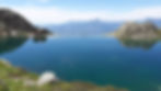
LAUVITEL LAKE
Located at an altitude of 1530 metres, the Lauvitel lake is the largest lake in the Ecrins massif
CROZET LAKE
Considered one of the most beautiful lakes in the Belledonne chain, it is undoubtedly as wild as it is quiet.
It offers a breathtaking view of the Chartreuse natural park.
Whether you are leaving for the great adventure, or simply a section of the Hexatrek, discover the most beautiful landscapes of the route in pictures

DISCOVER THE 6 OTHERS STAGES
Vosges - Doubs - Jura


Stage 1 - The Great East
Discover the mystical landscapes of the Grand Est.
Between green forests and crystal clear waterfalls through the hidden treasures of Eastern France.
Distance
670 km
Elevation
21.200 m
20 à 35 J
Duration
Savoie - Beaufortain - Vanoise
.jpg)
Stage 2 - Northern Alps
Throughout the heart of the most beautiful mountain landscapes, hike and enjoy the beautiful vistas in the center of the exceptional Alps.
Distance
382 km
Elevation
22.500 m
15 à 30 J
Duration
Ecrins - Belledonne - Vercors
Stage 3 - Southern Alps
The Hautes-Alpes are a paradise for hikers who venture there. You will encounter magnificent natural areas at every corner.
Distance
497 km
Elevation
26.800 m
20 à 35 J
Duration
Cévennes - Tarn - Languedoc

Stage 4 - Gorges & Causses
Here, time and water have shaped the landscape and dug deep gorges. Creating high plateaux between the junctions of these rivers, this contrast offer HexaTrek hikers incredible views.
Distance
514 km
Elevation
14.300 m
15 à 25 J
Duration
Catalogne - Ariége - p.esp

Stage 5 - East Pyrenees
The itinerary of this stage crosses the borders continuously, between France, Andorra and Spain. You will remain in the heart of the Pyrenean range, close to the summits.
Distance
532 km
Elevation
30.600 m
25 à 35 J
Duration

